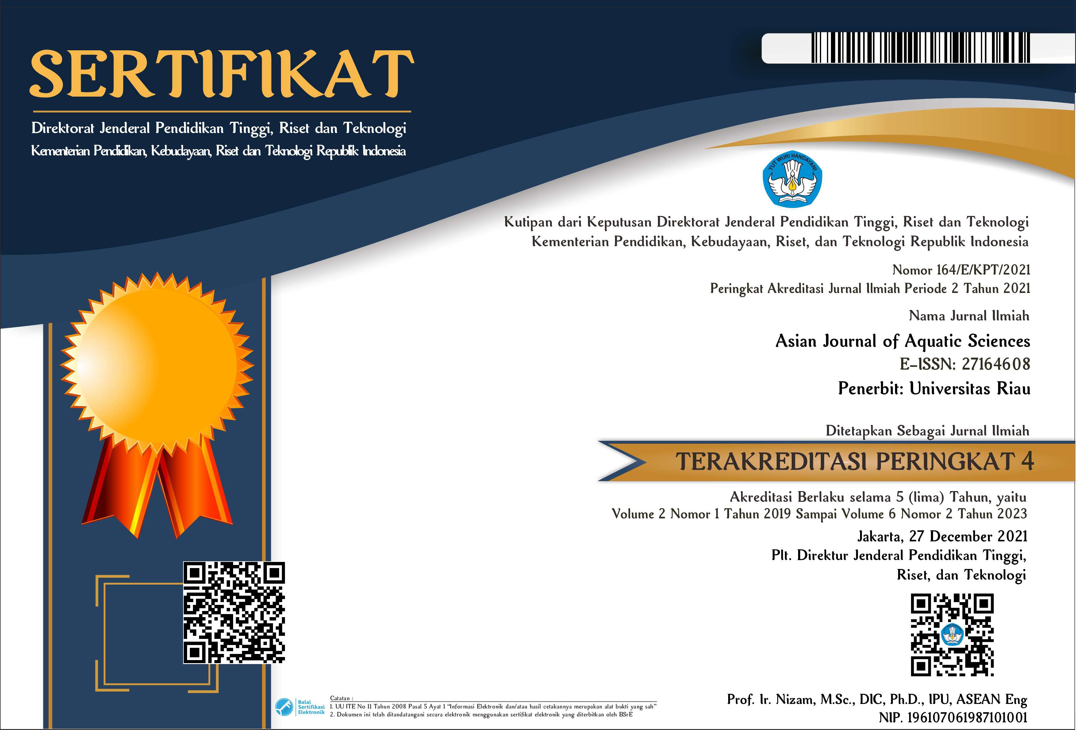
MANGROVE FOREST EFFECT ON THE COASTLINE IN RANGSANG ISLAND RIAU PROVINCE
Abstract
The study was conducted in May-June 2019 on Rangsang Island. This study aims to determine the effect of mangrove forests on coastline found on the island of Rangsang in Riau Province. The sampling location was determined by purposive sampling, namely 3 station points, namely Segomeng Village, Tanjung Kedabu Village, and Sungai Gayung Kiri Village. Landsat image data analyzed at the Oceanographic Physics Laboratory of the Department of Marine Sciences, Faculty of Fisheries and Maritime Affairs, University of Riau. To find out the area of mangroves using Landsad 5 TM satellite imagery and Landsat 8 OLI Tirs imagery and analyzed using Er Mapper Software, Envi 4.5 and Arcgis 10.3. Calculation of the structure of the mangrove community is carried out using the line plot plot method. The results of the analysis of the vast landsat image of mangroves in the coastal areas of Rangsang Island in 1997, 2002, 2007, 2013, 2019 were respectively 11,093 ha, 10,807 ha, 10,393 ha, 10,121 ha and 9,971 ha. Changes in the coastline indicate the occurrence of abrasion and accretion, where the highest abrasion occurs at station three with an average of -7.6 m/year and accretion occurs at station one with an average of 2.68 m / year. Mangrove density at station one is 2266.7 ind / ha and at station two that is 1466.7 ind / ha. Mangrove species found were Rhizophora apiculata, Rhizophora mucronata, Avicennia alba, Sonneratia ovata, Bruguiera gymnorrhiza, and Xylocarpus granatum.
Downloads
References
Dahuri, R., J. Rais., S.G. Putra, dan M.J. Sitepu. (2001). Pengelolaan Sumber daya Wilayah Pesisir dan Lautan Secara Terpadu. PT. Pradnya Paramita, Jakarta.
Hakim A.R., S. Sutikno, dan M. Fauzi. (2014). Analisis Laju Abrasi Pantai Pulau Rangsang di Kabupaten Kepulauan Meranti dengan Menggunakan Data Satelit. Jurnal Sains dan Teknologi.Volume 13(2), Pages 57-62.
Fadlan, M. (2010). Aktivitas Ekonomi Penduduk Terhadap Kerusakan Ekosistem Mangrove di Kelurahan Bagan Deli Kecamatan Medan Belawan. Universitas sumatera utara. Medan
Halida. (2018). Pemetaan Perubahan Luas Mangrove Menggunakan Citra Landsat di Kecamatan Rangang Barat. Skripsi. Fakultas Perikanan dan Kelautan Universitas Riau. Pekanbaru.
Hendrawan. J.I. Gaol dan S.B. Susilo. (2018). Studi Kerapatan dan Perubahan Tutupan Mangrove Menggunakan Citra Satelit di Pulau Sebatik Kalimantan Utara. Jurnal Ilmu dan Teknologi Kelautan Tropis, Volume 10(1), Pages 99-109
Nontji, A. (2005). Laut Nusantara. Cetakan Keempat. Djambatan. Jakarta.
Pinastika. N., S. Subiyanto, dan B. Sasmito. (2013). Pemetaan Total Suspended Solid (TSS) Menggunakan Citra Satelit Multi Temporal di Danau Rawa Pening Provinsi Jawa Tengah. Jurnal Geodesi Undip, Volume 2(4), Pages 72-84.
Setyawan, A.D., A. Susilowati, dan Sutarno. (2002). Biodiversitas Genetik, Spesies dan Ekosistem Mangrove di Jawa Petunjuk Praktikum Biodiversitas: Studi Kasus Mangrove. Jurusan Biologi. Fakultas Matematika dan Ilmu Pengetahuan Alam. Universitas Sebelas Maret. Surakarta.
Authors submitting manuscripts should understand and agree that the copyright of manuscripts of the article shall be assigned/transferred to the "Asian Journal of Aquatic Sciences". This work is licensed under a Creative Commons Attribution-NonCommercial-No Derivatives 4.0 International License, where Authors and Readers can copy and redistribute the material in any medium or format, as well as remix, transform, and build upon the material for any purpose, but they must give appropriate credit (cite to the article or content), provide a link to the license, and indicate if changes were made. If you remix, transform or build upon the material, you must distribute your contributions under the same license as the original.